

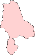
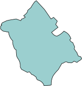
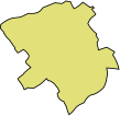


The Parish is made up with four maps as shown here.
Click a raised button on any map to display the image which you can navigate using zoom and pan.
Be aware that not all the maps are orientated North-South
Gnosall
Knightley
Gnosall
Heath
Coton
Plardiwick
Befcote
Hollies
Wilbrighton
Coley
Outwoods
Moreton
Bromstead
Heath
Walton
Grange
Great
Chatwell
Gnosall Parish - 1838 Tithe Maps
With grateful acknowledgement to:
© Staffordshire and Stoke on Trent Archive Service, by permission.
Tithe apportionment map, Gnosall – Apeton and Alstone, and Gnosall
Staffordshire Record Office, B/A/15/140, part 1)
Tithe apportionment map, Gnosall – Befcote, Coton End, Cowley and Plardiwick
(Staffordshire Record Office, B/A/15/140, part 2)
Tithe apportionment map, Gnosall – Knightley
(Staffordshire Record Office, B/A/15/140, part 3)
Tithe apportionment map, Gnosall – Walton Grange, Wilbrighton and Moreton, and
Great Chatwell - (Staffordshire Record Office, B/A/15/140, part 4)

The Tithe Awards index is available on the top of each map and elsewhere on this website
at: Places/Old Maps/1838 Tithe Awards. Also on the “Staffordshire Name Indexes”
website: https://www.staffsnameindexes.org.uk/default.aspx?Index=P
Cowley


